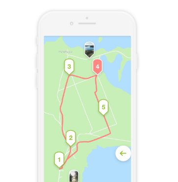
Bijota educational trail
The length of the route is ~3.5 km
Place – Bijota and Širvinto forests, between Dusia and Metelis lakes (Lazdija district)
The starting and ending point is at the Metelei Regional Park visitor center, near the swing (WGS coordinates – 54.283968, 23.741395 ). The trail is circular.
It will take you 1 hour. 15 minutes
The distance from Alytus is 31 km
The surface is natural soil (sand, soil), in the swamp - plastic floating sedge.
The trail is marked with green and white stripes on tree trunks. Information boards are placed in the most interesting places. It is recommended to travel in a clockwise direction. It is possible to travel independently or with a guide from the regional park directorate by booking a sightseeing tour in advance.
Specialists of the directorate conduct educational activities for students on the trail: "Through the forests and marshes of the inter-lake region", "Swamp ecosystem", "Knowledge of forest ecosystems - herbaceous plants".
Places of interest near the educational trail: Visitor center (30 m), Metelii observation tower (1.5 km), Great and Drevėtas Širvintos oaks (0.8 km and 1 km), Cross sanctuary (5 km), Prelomciškė mound (12 .5 km). The distance from the beginning of the educational trail to the object of interest by bike or car is indicated in parentheses.
Other details . The car can be left in the spacious asphalted parking lot. 350 meters from the start of the trail, the trail forks. By choosing the right branch, you would cover a shorter trail route of 2.9 km.
VšĮ Lazdijai tourism information center
Kaunas str. 6A, LT-67128 Lazdijai
www.lazdijai-turizmas.lt
email p.: info@lazdijutic.lt
Tel. +370 318 51881


Reviews